Ready... Set... Think!
By Douglass K. Daniel
Photographs by Lori Hawkins
New England Scouts test their orienteering skils in an annual race against time and terrain.
A crisp wind swirled fallen leaves along the trail Webelos Scouts Connor Dunn and Chris Conery hoped would lead them to victory. With just one checkpoint to go, they hurried ahead, feeling good about their race.
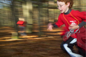 Patrick McWilliams, Troop 114, Bedford, N.H., races through the orienteering course to his next checkpoint. |
Accuracy and speed are everything in the sport of orienteering, where competitors use a topographic map to find specific locales—called controls and designated with flags—along a course in the quickest time possible. The two members of Pack 114 in Bedford, N.H., had been reading their map and staying alert to the landmarks around them—or so they had thought.
Instead of finding the finish line in sight, they were staring at a paved road. Their map indicated a road, all right, but one that represented a border along the far western edge of the wooded Nobscot Scout Reservation, a more than 450-acre camp owned and operated by the Framingham, Mass.-based Knox Trail Council.
Had they missed a feature on the terrain? Made a wrong turn? Whatever the case, Connor and Chris were lost.
“We weren’t following our map carefully,” Connor said later. “We got all messed up.”
The boys had no choice but to retrace their steps, losing valuable time in their bid for a trophy in the New England Scout Orienteering Championships—called the Scout-O for short.
“Orienteering is a skill as well as a sport,” said Betty Falxa, who started the Scout-O in 1988 and has been the event director ever since. “Whether you’re hunting, hiking—anything where you are out-of-doors—you are going to need map skills.”
A quick way to get lost
As challenging mentally as it is physically, orienteering demands the sureness of the tortoise as well as the hustle of the hare. Speed means little if you are on the wrong trail, take a wrong turn, or otherwise misread the map.
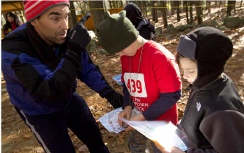 Spenser Hukull and Tristan MacDonald get last minute tips at the starting line from Tristan's dad. |
“It’s not the fastest person who wins,” said Cameron Owens, 17, a Scout with Troop 21 in Framingham, Mass. “You don’t want to go too fast for your mind. You want to think.”
Last fall, more than 400 competitors from Boy Scout and Girl Scout troops gathered at Nobscot in Sudbury, Mass., about an hour’s drive west of Boston. Nearly 50 volunteers—many from the New England Orienteering Club—were on hand to provide support, everything from emergency medical care to a well-stocked snack bar.
The orienteering club sponsors the annual Scout-O event on the last weekend of October, a cool time for a romp in the woods. Three months of planning and nearly 20 years of experience keep the event on a steady course.
“We have been able to offer this event because we have a dedicated core of Scouters who also orienteer,” said Pete Lane, event registrar and active Scouter who is a unit commissioner, assistant Venture Crew Advisor, and high adventure coordinator for the Knox Trail Council.
Lessons before the race
A few weeks before the event, the club offers Scout leaders and others a quick course in orienteering instruction that they can pass along to their troops or packs.
“We build expertise into the troops that way,” Betty Falxa says.
When the two-day event begins on Saturday, nearly 20 orienteering club members provide instruction to Scouts who need a brushup on their skills or a beginner’s lesson in working with a map.
Using a compass in orienteering is secondary to the ability to read the map and see the terrain, says Ken Menzies, Scoutmaster of Framingham’s Troop 21, an orienteer and one of the event’s organizers.
“It’s far more useful to keep the map visually oriented than to read compass bearings and run so many feet into the woods,” Menzies advises.
“Any cumbersome calculation slows you down to the point that you will never run a fast course,” he says. “It’s more fun to look for turns in trails, trail junctions, hilltops, and boulders while you run along the course.”
Learning by getting lost
In the competition, pairs of Scouts took on one of three courses according to the highest rank of their team members. Webelos Scouts and Boy Scout Tenderfoots were on the White Course, Second and First Class Scouts on the Yellow Course, and Star Scouts and above on the Orange Course.
The difference? The White Course was the shortest and easiest, never veering off a trail. The more complex courses were longer, the controls were farther off paths and trails, and flags were not always in plain sight.
“Getting ‘lost in the woods’ is both the best teaching experience and a character builder,” Menzies said.
Each team received a control card, a detailed map of Nobscot—in a plastic bag in case of rain—with their course marked on the map. (Betty Falxa planned the three courses and produced five-color topographical maps with the flag positions printed on them for each competitor. A volunteer set out the controls and flags the day before.) The first teams began at 9:30 a.m., with others following at two-minute intervals. Control cards were checked and times noted at the finish line.
Teamwork for time
Brothers Cameron and Alex Owens of Troop 21 took a sprinter’s stance at the starting line as their time neared. They planned to run the entire advanced Orange Course in order to post the fastest time.
Their strategy sounded foolproof: Cameron would bolt for each control and punch their control card while Alex studied the map and set their next route.
“He runs fast, and he runs often, and he’s got good eyes,” Alex said. For his brother’s part, Cameron said, “He’s a good navigator for pointing out ‘catching features’ and making a good plan of attack.”
“Catching features” are landmarks that lie beyond a control and signal when a team goes off course. They “catch” an error. For example, a rock wall that is beyond the course you have set is a sign that you have gone too far.
“There’s a lot of strategy in knowing what to do—but also knowing how to re-assess your position and re-orient yourself,” Betty Falxa said.
A muddy mistake
The Owens brothers were on the go. At times they veered off the beaten path to “bushwhack”—cut through the woods to create a more direct line between checkpoints.
Bushwhacking comes with its own risk. Misreading the map just a bit can mean becoming lost or passing a turn. There is also the rough terrain to deal with.
And the rough terrain caught up with Team Owens. First, they ran through a patch of thorny bushes that scraped and slowed them. Then Cameron put his foot down into a soft patch of earth—so soft that his leg disappeared almost to the knee. He pulled his leg out but left behind his shoe in the mud.
“Come on, let’s go!” Alex shouted behind him. “You’re falling behind!”
The brothers overshot Control 5, going too far to the right of a stone wall. When they reached a swampy area marked on the map, they realized their mistake. The minutes those mishaps cost them could make the difference between winning and losing.
Eyes ahead of minds
Between Controls 5 and 6, David Schunk and Patrick Watson of Bedford’s Troop 414 thought they were on the right track as well—until they came to the road designating Nobscot’s western border.
“This isn’t good,” David said.
“We need to go back and look at the map,” Patrick said.
Later, while they awaited race results, Patrick, an 11-year-old new Boy Scout, acknowledged that they had allowed their eyes to get ahead of their minds. “We didn’t look at the map when we finished [Control] 5, and we went straight and missed one of the turns,” he said.
Added David, a Tenderfoot Scout: “The map is your best friend. You should keep looking at your map.”
More than a trophy
Pack 114’s Connor Dunn and Chris Conery had already overcome one problem: They had lost their control card midway through the race. Someone found it in time for them to keep moving ahead. In spite of being lost for a while, they completed the course in well under an hour.
Their time—45 minutes, 49 seconds—couldn’t beat the best White Course time of 21:18. But discovering and correcting mistakes and still finishing the race was their achievement for the day.
“We were so hopeless,” Connor said later. “But we got back on track.”
On the more advanced Orange Course, the Owens brothers finished in 37 minutes, 51 seconds. Their boggy bungle may have cost them first place: The winning time in their category was 35:33. Still, being the runners-up in a field of 31 wasn’t bad. And Cameron and Alex left with more than a second-place trophy.
“Orienteering teaches you to slow down and think about what you’re doing,” says Cameron. “The experience teaches you patience.”
Douglass K. Daniel is an editor in the Washington, D.C., bureau of The Associated Press.
ON THE WEB: Read about another annual orienteering event, the popular Score-O competition in the Longhorn Council based in Fort Worth, Tex, at www.scoutingmagazine.org/issues/0109/a-long.html.
Orienteering: The Thinking SportOrienteering is very popular in Europe, where it originated in Scandinavia at the turn of the 20th century. Before then, using map and compass to cross unknown territory was mainly a military exercise. As a competitive sport, orienteering expanded slowly from the Nordic countries to other parts of Europe. Its popularity grew after World War II, and it gained more and more attention in North America. The United States joined the International Orienteering Federation in 1973. New England Scout-O organizers recommend that Scout troops attend a local orienteering club event before trying to set up their own. Forming a partnership with a club is a good way to make the sport a part of troop activities. To find an orienteering club near you, go to the Web site of the U.S. Orienteering Federation: www.us.orienteering.org. For an international perspective, check out the International Orienteering Federation: www.orienteering.org. —D.K.D. |
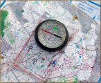
Six Tips for Reading a MapScout-O event director Betty Falxa knows her way around a map. She has competed three times at the World Orienteering Championships as a member of the U.S. team. ?Turn your map. Don’t always point the map to the north. Instead, turn the map in the direction you are going. Focus on features, not words. ?Know your colors. The five basic colors on a map symbolize features of the terrain. For example, blue means water while green means vegetation. Variations in color—dark green for thick vegetation—provide even more information. ?Know your symbols. They, too, have specifics meanings, such as a black dot for a boulder and a cluster of small dots for stony ground. ?Determine your route. Study the map to decide which route to your destination is best given the terrain. Check off features along the way to help you stay on course. ?Set a catching feature. Note a feature on the map that is beyond where you need to turn. If you reach it, stop—you have gone too far—and re-orient yourself. ?Fold, thumb, and turn. Fold the map to fit in one hand. Use your thumb to mark your location. Turn the map in the direction you are heading. Then get going. —D.K.D. |
 In teaching orienteering to younger Scouts, she emphasizes these basics:
Perfect Setting for OrienteeringThe Knox Trail Council’s Nobscot Scout Reservation is a perfect setting for an orienteering event. Its more than 450 acres include plenty of trees, hills, boulders, marshes, and other map-filling features. Nobscot Scout Reservation also provides lodges and other space for overnight group camping. And, most important for an orienteering event, the Scout camp has been carefully mapped for orienteering by the New England Orienteering Club. (Creating a detailed map of an area can cost $15,000 to $20,000.) The orienteering club provides the maps of Nobscot and equipment for the event. —D.K.D. |
 The word Nobscot, by the way, comes from the Algonquin Indians and means “place of falling rocks.”
September 2007 Table of Contents
Copyright © 2007 by the Boy Scouts of America. All rights thereunder reserved; anything appearing in Scouting magazine or on its Web site may not be reprinted either wholly or in part without written permission. Because of freedom given authors, opinions may not reflect official concurrence.