
Arkansas Traveling
Heed the call of the wild on the Buffalo River Trail.
By Larry Rice
Illustration by Steve Sanford
Photograph by Walter Meayers Edwards
The swift-moving Buffalo National River winds 130 miles through the Ozark Mountains of northwestern Arkansas. Managed by the National Park Service, it exists as one of the longest stretches of free-flowing water in the Lower 48. You can see this near-wilderness of hills and sculpted side hollows, forests, and meadows by canoe tripping. But try backpacking the 37-mile Buffalo River Trail, easily one of the best hikes around.
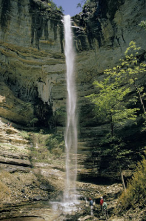 Hikers view the Hemmed-in-Hollow waterfall. |
Located for much of its length in the 11,300-acre Ponca Wilderness Area, the steep and rocky trail passes rugged, wild areas that best characterize the park. It’s where you’ll find the river’s highest bluffs, along with jumbled canyons, shaded glens, and fern-draped hollows splashed with waterfalls.
You may think you’re in shape for an Ozarks hike, but you’ll know for sure a few minutes after leaving the Ponca trailhead. Sometimes hugging the river, sometimes offering expansive views atop the crests of hardwood-clad ridges, the route puts you into Dogpatch backwoods that canoeists never see.
Along the way you’ll encounter the 500-foot-tall Big Bluff (one of the tallest cliff faces in mid-America), the cascades of Beech Creek, the historic Parker-Hickman log house (built around 1840), and two cemeteries that date back to the Civil War. Unexplored caves and ancient Native American encampments lend an air of mystery to the dells. The path moves through gentler terrain the final few miles, passing a spring-fed pond that attracts birds and other wildlife.
More than 10 million people live within 250 miles of the Buffalo River. Yet the trail is a haven of tranquility. Here, where Southeast meets Southwest, armadillos, roadrunners, and tarantulas co-exist with whitetail deer, bobcats, and black bears.
Fishing fanatics take note: The clear, mint-green Buffalo River and its tributaries earn notice for the number of fish species—among the most diverse in the nation. The game fish of choice? Bass.
When the level of river dips low enough to ford (usually from late summer through winter), don’t miss the 2.5-mile side hike (one way) to Hemmed-in-Hollow. A trail on the Buffalo’s north bank leads into a narrow, dead-end canyon, backdrop for a 209-foot, free-leaping waterfall, the tallest of its kind between the Southern Appalachians and the Rockies. But beware the slippery, water-polished rocks.
 The Ponca Wilderness might be pint-size by Western standards, but it’s still wild. Consider a compass and topo maps essential.
Most people prefer hiking the Buffalo River Trail in the spring and early summer. I like late fall when the leaves turn golden and red and all the creepy, crawly things are dormant. Don’t be surprised, as I was last October, if you hear the passionate, high-pitched bugling of elk. The Arkansas Game and Fish Commission and the National Park Service reintroduced the species to this area in 1981, and more than 400 live adjacent to the river.
Coupled with the sharp bite of autumn air, the elks’ haunting vocalizations represent one of the Arkansas Ozarks’ most powerful and memorable experiences.
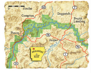
ACCESS: To reach the trailhead, take I-40 roughly 100 miles west of Little Rock and turn north on Highway 21 at the town of Clarksville for about 55 miles to the town of Ponca.
CAMPING/PERMITS: Camping allowed on gravel bars along the river and in all backcountry areas—with some restrictions. No designated campsites; permits not required.
CONTACT: Buffalo National River, 870-741-5443; nps.gov/buff. Purchase maps and guidebooks at the park visitor center.
Larry Rice is a contributing editor for Canoe & Kayak magazine and the author of Gathering Paradise: Alaska Wilderness Journeys.